

MAP
FRANKLIN COUNTY, MISSISSIPPI
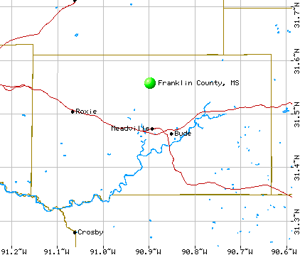
FRANKLIN COUNTY, MISSISSIPPI
1990 Population 8,377
Latitude 31.47750 N /// Longitude 90.89805 W
Western Boundary: Adams Co., MS / Natchez, MS
Northern Boundary: Jefferson Co., MS / Fayette, MS
Eastern Boundary: Lincoln Co., MS / Brookhaven, MS
Southern Boundary: Amite Co., MS / Liberty, MS
Southwestern Boundary: Wilkinson Co, MS / Woodville, MS
County Seat: City of Meadville / 1990 Population / Zip Code
Other Communities in Franklin County:
Beam's Store (historical) near Little Springs
Bonus near Kirby
Buckley's Ferry (historical) by Homochitto River
Bude on Highway 84 east of Meadville
Bunkley near Homochitto River
Butler (historical) near Meadville
Celco (historical) near McCall Creek
Dick near Bude
Eddiceton
Flat Rock near Knoxville
Franklin near Knoxville
Freewoods near Crosby
Garden City
Hamburg near Roxie
Helena (historical) near Cranfield
Kennolia near McCall Creek
Kirby
Knoxville
Little Springs
Lucien near McCall Creek
McCall Creek on Highway 84 near Lincoln County line
Meadville on Highway 84 east of Roxie
Monroe near Bude
Mount Olive near Homochitto River
New Hope near Eddiceton
Oldenburg near Kirby
Orange near Roxie
Portersville (historical) near Roxie
Quentin on Highway 84 west of McCall Creek
Rights Ford near McCall Creek
Roxie on Highway 84 west of Meadville
Shucktown near McCall Creek
Suffolk near Meadville
Tubbyville (historical) near Knoxville
Turners (historical) near Cranfield
Veto near Eddiceton
Wheats (historical) near Eddiceton
White Apple near Knoxville
Whittington near Busy Corner

THIS PAGE COPYRIGHT 1998-2009
BY CAROLYN JEAN ADAMS SWITZER.
ALL RIGHTS RESERVED.
This information may be used by libraries and genealogical
societies, however commercial use of this information
is strictly prohibited without prior
permission of the owner. If copied, this copyright notice must appear with the
information.