COMMUNITIES OF TATE COUNTY, MS
(Sources listed at bottom)
![]()
Aiken (1, 3, 4)
Antioch (1, 3, 4)
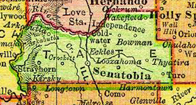
Arkabutla (1, 2, 3, 4)
Barr (1, 2, 4)
Beach Point (1, 3)
Bett (1, 3, 4)
Bowman (1, 2, 3, 4)
Coldwater (1, 2, 3, 4)
Cottonville (1, 3)
Crockett (1, 3)
Cupid (3)
Cypress Corners (1, 2, 3, 4)
Eckles (2, 3, 4)
Eliphaz (1, 3, 4)
Flag Lake (3)
George Point (3)
Goode (1, 3, 4)
Greenleaf (1, 3, 4)
Hudson (3)
Independence (2, 3, 4)
Irwin (2, 3)
Kelly's Crossing (1, 3)
Linwood (1, 3, 4)
Locust (3)
Looxahoma (1, 2, 3, 4)
Lurlyne/Lurline (1, 3, 4)
Mabry (3, 4)
M-Ville (3)
Midville (3)
Murry (extinct) (1, 2, 3)
New Garden (3, 4)
Newtown/New Town (1, 3, 4)
Palestine (extinct) (1, 3)
Peak (3)
Poagville/Poogville (1, 3)
Poplar (3)
Rainey (2, 3)
Rich (3)
Salem (3)
Sarah (3, 4)
Savage (1, 3, 4)
Scotland (3)
Senatobia (1, 2, 3, 4)
Singleton Springs (3)
Sloan (3)
Spring Hill Grange (3)
Springfield (3, 4)
Strayhorn (1, 2, 3, 4)
Tatesville (historical) (1)
Tatumsville (historical) (1, 3)
Taylor (3)
Thyatira (1, 2, 3, 4)
Truslow (3)
Tyro (1, 2, 3, 4)
Wakefield (1, 3, 4)
Wyatte (1, 3, 4)
Sources of Information
(1) USGS GNIS
(2) 1895 US Atlas
(3) The Heritage of Tate County, by Tate County MS Genealogical & Historical Society, Inc., 1991
(4) Hometown Mississippi, by James F. Brieger, 1980, 1997
![]()
Landmarks/Historical
Hudson's Ferry (historical), Arkabutla West
Thompsons Ferry (historical), Arkabutla West
McGehee's Crossing, (extinct) 3 1/3 miles south of Senatobia
Cotton Platform, (extinct) (picture taken abt 1898 hangs on TCGHS wall) Senatobia
Circle M Ranch, (extinct) (M. P. Moore's World Famed Polled Herefords) Senatobia
Brown's Ferry, (extinct) west of Senatobia
![]()
This page updated January 19, 2010


Tate County Coordinators: Syble Embrey & Marie
Carlton
All rights reserved. Copyright of submitted items belongs to those responsible for their authorship or creation unless otherwise stated.
![]()