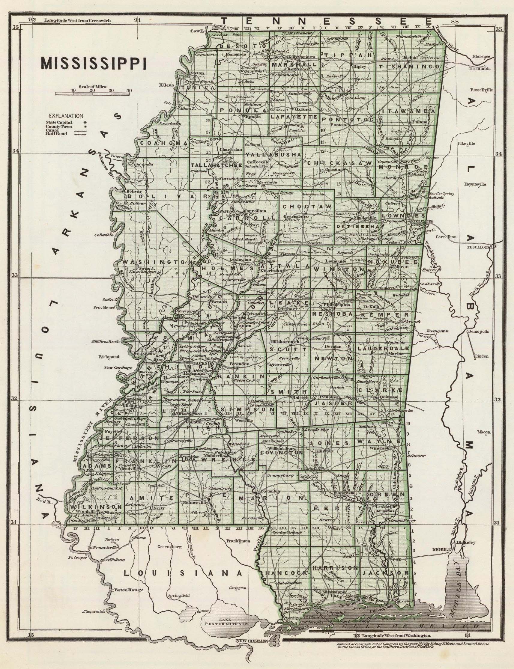
|
Cities/Towns
| Alton6 (historical) |
19031903, historical post office |
| Ashland (Benton County) |
|
| Atway1, 4, 6, 11 (extinct) |
1898-1911, originally known as Scale's Station, Hudsonville, Old Hudsonville, northeast of Holly Springs, historical post office, 6 miles north of Holly Springs |
| Bainsville4, 6 |
1884, later known as Cayce in 1888, historical post office |
| Barton1, 2, 4, 11 (historical) |
before 1860, originally known as Oak Grove; historical post office 1884-1906; a post-hamlet in the extreme northwestern corner of Marshall county, near the Tennessee line, 18 miles distant from Holly Springs, the county seat, and about 6 miles north of Byhalia, the nearest railroad station. Population in 1900, 45. |
| Beloil6 |
historical post office, 18751875, moved to DeSoto County |
| Beth6 |
historical post office 1906-1907 |
| Bethlehem1, 2, 4, 9, 11 |
1852, southern part of Marshall County. It was named after the Methodist church. The oldest cemetery in the county is believed to be in Bethlehem. Post office 1860. A post-village in the southeastern part of Marshall County, about 15 miles southeast of Holly Springs. Population in 1900, 300.
|
| Blackwater1 |
Laws Hill |
| Byhalia1, 2, 4, 5, 8, 9, 11 |
1832, northwest of Red Banks, located on the old Pigeon Roost Road. The Waverly Institute was established in 1881 by Professor and Mrs. A.M. Moore and the Katie Tucker Institute was established in 1883 by Miss Katie Tucker. These schools were combined in 1900 to form the Byhalia High School, located on the old Waverly site. Post office 1846, 1860, and 1870.
An incorporated post-town in the northwestern part of Marshall county, is a thriving station on the Kansas City, Memphis & Birmingham R. R., 16 miles northwest of Holly Springs, and 28 miles by rail southeast of Memphis. The name is an Indian word meaning "standing white oaks". It is located in a good cotton district. It has three churches, two select schools, several general stores, two cotton gins, an agricultural implement factory, and a Democratic weekly newspaper, the Journal, established in 1883, edited by S. C. Mims, Jr. The Byhalia branch of the Merchants' and Farmers' Bank of Holly Springs were established here in 1903. The town is supplied with an electric light and water-works system. Population in 1900, 760, which is an increase of more than 75% in ten years; in 1906 the estimated population was 1,000. |
| Callahan's Ferry1, 2, 3 |
|
| Cayce1, 2, 6, 11 |
1880-1886, historical post office 1888-1907, originally known as Bainsville, at Victoria and Collierville Roads, near Collierville, established before the Civil War. The land was originally owned by Mr. Bain.
a post-hamlet in the northern part of Marshall county, about 16 miles northwest of Holly Springs. Population in 1900, 36. |
Chewalla6, 11
(historical) |
post office 19041908 |
Chewalla Mills6
(historical) |
post office 1872-1877 |
| Chewalla Organization Camp1 |
Potts Camp |
| Chulahoma1, 2, 4, 5, 6, 9, 11 |
1830-35, originally known as Tucklahoma, southwest of Marianna. The Chulahoma Female College was burned during the Civil War. Post office 1846, 1860
an incorporated post-village in the southwestern part of Marshall county, located on Cuffawa creek, about 10 miles southwest of Holly Springs, and about 48 miles southeast of Memphis, Tenn. Chulahoma is an Indian word meaning "red fox". It has a money order postoffice, three churches and an academy. Population in 1900, 57. |
| Coal Oil Corner1 |
|
Colbert1, 2, 6, 11
(historical) |
post office 1879-1909, a post-hamlet of Marshall county, about 10 miles northeast of Holly Springs |
| Coldwater9 |
post office 1860 |
Coleman2, 6, 11
(historical) |
post office 1872-1909; a post-hamlet of Marshall county, 7 miles southwest of Holly Springs. Population in 1900, 22. |
Conrad1, 6
(historical) |
post office 1872-1909 |
| Cornersville1, 2, 4, 9, 11 |
southeastern corner of Marshall County, was on the Old Indian Trail. At one time it was used as a horse station for stagecoaches. It is older than Holly Springs and was incorporated at one time, but the town charter was later surrendered. Post office 1860.
A post-hamlet of Marshall county, about 24 miles southeast of Holly Springs, the county seat. It has a church and several stores. Population in 1900, 165. |
| Cross Roads4 |
later known as Oak Hill then Warsaw |
| Early Grove1, 2, 4, 8, 9, 11 |
north of Slayden, post office 1860, 1870; a post-hamlet in the northeastern corner of Marshall county, 15 miles north of Holly Springs, the county seat, and 6 miles west of Michigan City, the nearest railroad town. It has two churches. Population in 1900, 42. |
| Forest4 |
later known as Gilton |
| Galena1, 2, 4, 6, 11 |
1832, settled by William Henry Coxe, historical post office 1891-1911; a post-hamlet of Marshall county, 10 miles southwest of Holly Springs, the county seat. Population in 1900, 50. |
| Gilton1, 4 |
1870s, originally known as Forest |
Glenn6
(historical) |
1887-1888 |
Goodmans Ferry1
(historical) |
|
Goodmans Mill1
(historical) |
|
| Gourd Neck4 |
now known as Slayden |
Grin Wolf1, 5
(historical) |
post office 1846 |
Higdon1, 4, 6, 11
(historical) |
post office 1894-1909; a postoffice of Marshall county, about 4 miles east of Holly Springs, the county seat. |
| Holly Springs1, 2, 4, 5, 9 |
originally called Suavatooky, Post office 1846, 1860 |
Hopeville1
(historical) |
|
Hudsonville1, 2, 4, 5, 8, 9
(extinct) |
1830s, originally known as Scale's Station, Hudsonville, then Old Hudsonville became Atway, Post office 1846, 1860, and 1870
Hudsonville10 - The town of Hudsonville was about four miles southwest of old Lamar on the stage road that ran from Lagrange, Tenn., to Holly Springs, Miss. In January, 1837, this village sprang up as if by magic. It soon contained ten or a dozen new houses and several stores. Its acts of incorporation bear the dates of 1838 and 1844. It continued as a country town and furnished a retail trade until the present station of the same name was located about two miles southeast on the Illinois Central (then the Mississippi Central) railroad. The old town was then absorbed and becamed depopulated, only one family (Dr. Phillips') remaining. Prominent citizens then living in the vicinity were Peter Scales, Dabney Minor, the Daniels, Albert Hunt, John Roberts, Harvey Means, McFadden, J. R. Mayhon, William Arthur, Maj. Catrell, William Wall, and Kemp Holland. This town now exists only in the memory of the older inhabitants of North Mississippi. |
Ittawamba4
(extinct) |
1830s, settled before the formation of Marshall County. It was located three miles northwest of Holly Springs on land belonging to the Chipawa Indians. |
| Kenzie6 |
historical post office 19051907 |
| Lake Center1, 4 |
southeast of Holly Springs |
| Lamar5, 8, 9 |
post office 1846, 1860, and 1870; currently located in Benton County. |
| Laws Hill1, 2, 4, 6, 11 |
formed before 1860, historical post office 1875-1911. Named after Mr. Law who owned the general store which was on a hill. A post-hamlet in the southern part of Marshall county, about 15 miles southwest of Holly Springs. Population in 1900, 20. |
Lebanon
historical |
post office 188019046; a postoffice of Marshall county, 12 miles south of Holly Springs, and 4 miles southwest of Potts Camp, the nearest railroad town on the Frisco system.11
EVANS SETTLED LEBANON: Alexander M. Evans with his wife Sophronia [Buffington] and nine children, came by way of covered wagons from Hall County, Georgia, to Marshall County, Mississippi, the latter part of the Civil War and settled Lebanon Community, about 15 miles south of Holly Springs. He named the new community Lebanon because of the many cedar trees. He built the first home and homestead enough land to give each one of his children about 180 acres as they married. Mr. Evans built the first church, which has been replaced by the present beautiful white church, near the cemetery where three generations of Evans relatives are buried. He chose the site of the cemetery. Each year on the third Sunday in May relatives and friends gather for Homecoming Day at Lebanon Church, and celebrate with ole time singing, a walk through the cemetery and share memories of days gone by. [The South Reporter, date unk] |
Luck1, 4, 6
(extinct) |
was located near Mt. Pleasant, historical post office 1896-1903, Sullivan General Store near TN State line. Marshall Institute was located there. Luck was named after Squire Luck. |
Mack1, 4, 6, 11
(extinct in 1909) |
historical post office 1894-1909, originally known as Stephenson Place. This town was named after the MacAlexander family. A postoffice of Marshall county, 6 miles northwest of Holly Springs, the county seat. |
| Mahon1, 2, 4, 6, 11 |
historical post office 1890-1919; a post-hamlet of Marshall county, on the Kansas City, Memphis & Birmingham R. R., 4 miles northwest of Holly Springs. Population in 1900, 41. |
| Malone1, 4, 6 |
originally called Malone's Tank, south of Waterford, east of Laws Hill, historical post office 1898-1922, originally Nick. Train locomotives were filled with water for steam at Malone's Tank. It was named after Dr. Malone, a large plantation owner. |
| Marianna1, 2, 4, 6, 11 |
1875, originally situated ¼ mile from its present location, historic post office 1886-1911, originally Waco. Settled by Martin Greene and Sam Mimms. Their wives' names were combined to name the town. A postoffice of Marshall county, about 8 miles west, southwest of Holly Springs, the county seat. Population in 1900, 23. |
Marshall Turnpike6
(historical) |
post office 18521857 |
Milton
(historical) |
see MS 1845 map |
Moody1, 3, 9
(historical) |
also post office 1860 |
| Mt. Pleasant1, 2, 4, 6, 11 |
1830s, originally known as Pleasant Mountain. Also known as North Mt. Pleasant post office 1837, name changed in 1871. It was named after the Pleasant family. There were two schools there in 1855, a female academy which may have been burned during the Civil War and a male academy that was razed in 1903. An incorporated post-town in the northern part of Marshall county, about 15 miles north of Holly Springs. It has two churches. Population in 1900, 139. |
Nick6, 11
(historical) |
post office 1898, name & location changed to Malone 1908
Nick or Malone Station - a postoffice of Marshall county, on the Illinois Central R. R., 14 miles by rail south of Holly Springs.11 |
Nicksville6
(historical) |
post office 18821882 |
| North Mt. Pleasant5, 8, 9 |
Post office 1846, 1860, and 1870 |
| Oak Grove4, 9 |
later known as Barton, post office 1860 |
| Oak Hill4 |
originally known as Cross Roads, later known as Warsaw,
see MS
1845 map (in DeSoto Co.) |
Oak Ridge1, 5
(historical) |
post office 1846 |
| Old Bethlehem1, 2, 4 |
|
Old Hudsonville4
(extinct) |
later known as Atway. It was located two miles west of the present Hudsonville. |
| Old Lamar |
|
| Old Salem |
|
Old Waterford1, 4
(historical) |
|
Orion1, 2, 4, 6, 11
(extinct) |
historical post office 1881-1911, was south of Red Banks; a post-hamlet of Marshall county, 12 miles southwest of Holly Springs, the county seat. Population in 1900, 20. |
Overpark1
(historical) |
|
Picket6, 11
(historical) |
post office 19001907; a hamlet in the southeastern part of Marshall County, 18 miles from Holly Springs, the county seat. It has a money order postoffice. |
| Pleasant Mountain4 |
later known as Mount Pleasant |
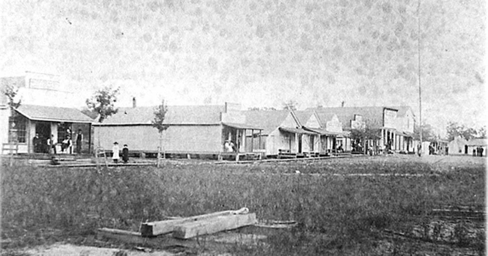
| Potts Camp1, 2, 4, 6 |
established as a levee camp in the 1870s, post office established 1875. Potts Camp was named after Colonel E.F. Potts, the first white settler in this section.
In the southeastern part of Marshall county, is an incorporated post-town, on the line of the Kansas City, Memphis & Birmingham R. R., about 13 miles southeast of Holly Springs, the nearest banking town. It was named in honor of Col. E. F. Potts. It has a money order postoffice. Population in 1900, 306.11
ca 1915-1916 Town Photos ~
PC Frontier Town ~
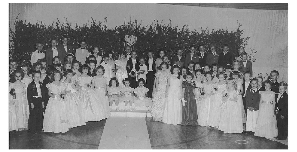
"Tom Thumb Wedding" ~
PC Class Photos ~
Duke Wright Greer House |
| Red Banks1, 2, 4 |
1820-1825, one of northwestern Mississippi's oldest communities, was settled by a group from North Carolina while the land was still owned by Indians
an incorporated post-town of Marshall county, on the Kansas City, Memphis & Birmingham R. R., 9 miles northwest of Holly Springs, the nearest banking town. It was so named because of the reddish appearance of the banks of the creek on which it is located. It has 2 churches, a money order postoffice and a steam gin. Population in 1900, 79.11 |
Reynolds Box1
(historical) |
|
| Sand Flats1 |
|
Scale's Station4, 9
(extinct) |
later known as Hudsonville, then Old Hudsonville, then Atway, post office 1860 |
Searcy6
(historical) |
post office 1888-1891 |
| Slayden1, 2, 4 |
1865, originally known as Gourd Neck then Slayden's Crossing, historical post office 1875-1909. Named for Everett Daniel Slayden.
Slayden or Slayden's Crossing - a post-hamlet in the northern part of Marshall county, 12 miles north of Holly Springs. Population in 1900, 26.11 |
| Snow Creek |
1856-1867, post office 1860, (Mt. Zion Cemetery Article) |
| Spraggins1, 4 |
1894, extinct in 1939, south of Holly Springs |
| Spring Creek2 |
|
Sylvestria>1, 4
(extinct) |
1832, extinct by 1925, northeast of Holly Springs. Sylvestria means church in the woods. |
Tacaleeche7
(historical) |
post office 1843-1878, later reopened & moved to Potts Camp |
Tacaluche1, 5, 9
(historical) |
post office 1846, 1860 |
Taft6
(historical) |
post office 1906-1907 |
Tallaloosa1, 4, 5, 9
(extinct) |
flourishing in 1839, extinct by 1861, southwest of Holly Springs on Pigeon Roost Creek. The name means black rock, which was taken from the Indian word Tall-lusa". The town eventually moved to Waterford to be near the railroad. Post office 1846, 1860.
The village of Tallaloosa was located in Marshall county, about eight miles southwest of Holly Springs, on the Pigeon Roost creek. It contained two or three small stores and a few families at the time of its greatest prosperity. Although it never became an important place, it was incorporated by the Legislature in 1838. It was surrounded by a good agricultural section. Major James Glover, the Woods family, the McClutches, the Hursts, John Williams, McCraven, William Jones and his two sons, Joel Echols, and others, settled in this vicinity. It was about extinct before the War between the States, being absorbed by Holly Springs and Chulahoma.10
Tallaloosa was an early settlement in Marshall County, 8 miles southwest of Holly Springs, and attained sufficient importance to be incorporated by the Legislature in 1838. It was located in a rich farming region, occupied by such families as the Glovers, Woods, McClatcheys, Hursts, Williams, McCravens, Jones and Echols. The town was absorbed by Holly Springs and Chulahoma, and is now extinct.11 |
Taska1, 4, 6, 11
(extinct) |
north of Red Banks, historical post office 1899-1924; a postoffice of Marshall county, 18 miles northwest of Holly Springs. |
| Tate6 |
historical post office 1906-1909 |
| Tucklahoma4 |
later known as Chulahoma |
Tyro6, 8, 9
(historical) |
post office, 1850, 1860, and 1870, originally named Gim Wolf, 1873 moved to Tate County |
Vance6
|
historical post office 18961896 |
| Victoria1, 2, 4 |
founded 1872, located on the Frisco Railroad between Red Banks and Byhalia. Mr. George Buchanan named the town for his wife.
a post-hamlet and station of Marshall county, on the Kansas City, Memphis & Birmingham R. R., 13 miles northwest of Holly Springs, the county seat, and nearest banking town. Population in 1900, 30. It has a church and a steam gin.11 |
| Waco |
historical post office 18801886; name changed to Marianna |
| Waites/Waits1, 2, 4, 6 |
originally known as Waites Siding, historical post office 1896-1916, northwest of Potts Camp. Named for Judge Gordentia White, a landowner.
a post-hamlet and station in the eastern part of Marshall county, on the Kansas City, Memphis & Birmingham R. R., 6 miles southeast of Holly Springs. Population in 1900, 24.11 |
Wallhill1, 2, 4, 6
(extinct) |
1820-1825, incorporated in 1875, extinct by 1936, historical post office, post office 1860, south of Chulahoma. It was founded by Mr. Billy Wall and was located on a hill.
an incorporated post-town in the western part of Marshall county, 17 miles west of Holly Springs, the nearest railroad and banking town. The place was named for William Wall. It has a church and a mill. Population in 1900, 65.11 |
| Warsaw1, 4, 6, 11 |
settled 1830s, originally known as Cross Roads then Oak Hill, historical post office 1902-1916. One of the oldest settlements in Marshall County, south of Byhalia. |
| Waterford1, 2, 4, 5, 8, 9 |
1840s, south of Holly Springs. Originally located two miles west of the present site, moved closer to the railroad when it was constructed. Post office 1846, 1860, and 1870.
Waterford10 - One mile west of the station of the same name on the Illinois Central railroad was located the village of old Waterford. It was once a lively little town and was incorporated by the Legislature in 1838. This place was at an early date the muster or drill ground of the militia for this part of the State, where the brigade under the command of Brigadier General Guy was reviewed once or twice a year. Its selection for this purpose gave it some prominence. Among the prominent citizens and planters of that community were Dr. Thomas J. Malone, Robert H. Malone, Shaderick Wooten, Alfred Brooks, Mr. Sherman, Samuel Cole, John Killough, John W. Mooring, Dr. Jones, and James Cherry. There are now no more houses standing on the site of old Waterford. The stream of Spring creek furnished an abundance of water for two grist mills, Sumpkin's and Ford's, at an early date. A gun and fishing club has recently erected a club house where the latter mill once stood. |
| Watson1, 2, 4, 6, 9 |
1850s, south of Byhalia, founded by I.T. Watson, historical post office 1852-1916. Originally located two miles west of present site, moved closer to the railroad when it was constructed.
a postoffice in the western part of Marshall county, 15 miles from Holly Springs, the county seat and nearest banking town.11 |
| Watson Center1 |
|
Sources of Information
(1) USGS GNIS
(2) 1895 US Atlas
(3) Merkentile Agency Reference Book, Vol. XIX, 9 Jul 1866, located at the MS Archives in Jackson
(4) Hometown Mississippi, by James F. Brieger, 1980, 1997
(5) 1846 U.S. Postal Guide of Towns in Marshall County, Information obtained from Lineages, Inc., website
(6) Source for opening & closing dates: The Post Offices of Marshall County, Marshall Messenger, March 21, 1984
(7) Memories of Potts Camp, by Dale Potts Hollingsworth, The South Reporter, June 26, 1980
(8) Post Office Directory, List of Post Offices in United States, Government Printing Office,
1870, Revised & Corrected by the Post Office Department, to September 1, 1870
(9) Post Offices and Postmasters
in Marshall County in 1860, by William S. Parks
(10) Extinct Towns and Villages of Mississippi, by Franklin L. Riley, Publications of the Mississippi Historical Society, Vol. V., Oxford, Mississippi, Printed for the Society, 1902. [Note by Franklin L. Riley: The writer is indebted to Maj. Wm. M. Strickland, Holly Springs, Miss., for information with reference to the extinct towns of Marshall county.]
(11) Mississippi - Comprising Sketches of Counties, Towns, Events, Institutions, and Persons, Arranged in Cyclopedic Form, planned and edited by Dunbar Rowland, LL.D., Vol. I.; Atlanta: Southern Historical Publishing Association, 1907.
Marshall County Mills
Blackwater Mill (Blackwater Creek) (1)
Boatwright's Mill (3)
Bradley Mill (Clear Creek) (1)
Bradley's Mill (Cuffawa Creek) (1)
Butler's Mill (Little Coldwater) (1)
Callahan's Mill (Tippah River) (1)
Carlock's Mill (Pigeon Roost Creek) (1)
Carnathan's Mill (Chewalla Creek) (1)
Clear Creek Mill (Clear Creek) (1)
Collins' Mill (Chewalla Creek) (1)
Davis Mill (Wolf River) (1)
Ford's Mill (Ford's Pond) (1)
Hunt's Mill (Pigeon Roost Creek) (1)
Jackson's Mill (Coldwater River) (1)
Kibbler's Mill (Tippah River) (1)
Lockhart's Mill (Coldwater River) (1)
Lumpkin's Mill (Lumpkin Pond Springs overflow) (1)
*McClatchy's Mill (Peyton Road) (2) - *John Hamilton MCCLATCHY, b. 3 October 1827, Iredell Co, NC, arrived c. 1839 with his father Hamilton McClatchy Jr. "His home on Peyton Road was rebuilt right after the Civil War. It had an orchard in front, a spacious yard, had a cotton gin, grist mill, blacksmith shop, and store. It received the mail before RFD was started. He took in stranded kinfolk, including the orphans Wm. HALTON and John KIZER. His son Frank's children lived with him after their mother died. The youngest, Katie Frances, lived there in the care of Katie Lee."
McNiell's Mill (Chewalla Creek) (1)
Morris Mill (Red Banks Creek) (1)
Parham's Mill (Coldwater River) (1)
Polk's Mill (Coldwater River) (1)
Quinn's Mill (Coldwater River) (1)
Tippah Mill (Tippah River) (1)
Tompkins' Mill (Coldwater River) (1)
Sources:
(1) Old Mills of Marshall County Article by
Hugh H. Rather, The South Reporter, 16 Apr 1998
(2) MCCLATCHEY Family Notes, unknown author, unpublished, this item has
been circulating in the McClatchey family for a number of years. Note: The McClatchy Mill was submitted by Beau Bowen.
(3) Reference in The Reporter, January 13, 1871
|